How we plan to present our findings on the Arb Website
Firstly, we wanted to provide further insight into all the information we’ve collected for the archaeological sites we interacted with during the class. The Arb Website seemed like the perfect place to give a detailed archaeological account of the historical value prevalent in each site. Hence, to main the ease of public accessibility, we proceeded to follow the preexisting format that exists on the Arb Website to ensure that it is a seamless addition.
While compiling information for the Arb Website, we concluded that we wanted to present our findings in a chronological fashion as it would be most understandable from the public’s perspective. We chose to specifically follow the format of The History of Willis Hall webpage as it is a prominent building within our locality that has its information presented coherently. This chronological format is also utilized by the Carleton History in the historical timeline section which further solidifies our choice for following this format.
For the sites with less readily available historical information, we chose the format that concentrates on summarizing essential information into easily comprehensible paragraphs. The summarization format can be seen in multiple instances including The History of Carleton’s First Wind Turbine webpage where additional information out of the chronology is condensed into paragraphs. Keeping this in mind, sites like the Millpond Dike will end up becoming subgroups of a main webpage like the Waterford Mill. Another commonality we noticed between all the web pages is that they provide additional pictures of the sites on the right-hand side of the page. Since we can’t place them in the same manner due to WordPress restrictions, we decided to upload the pictures as a gallery to display the pictures we would’ve chosen if these summaries were to go on the Arb Website. We chose a handful of pictures for each site that we felt would best supplement our text. Lastly, we adhered to the same format as The Willis History Hall webpage when providing resources to find extra information because it is concise and straight to the point.
As an additional note, the quarry site felt slightly like an anomaly as it couldn’t be on a main webpage but it did not fit in any webpage as a subgroup either. Therefore, we chose that it would be most appropriate if it goes on the How Humans Shaped the Arb interactive map under the Moving Rocks and Dirt section. This made the most sense from our perspective as it fit perfectly because the quarry was most likely physically shaped from human activities and it qualified for the interactive map criteria in terms of the amount of information presented.
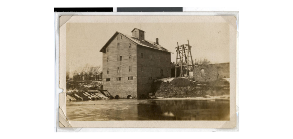
Cowling Arboretum | The History of Waterford Mill
The Waterford Mill Chronology
1855: The first mill in the Northfield vicinity was built paving the way for many others in the near future.
1873: The Cannon River Manufacturing company authorized a committee consisting of J. N. Bill, E. D. Bowe and E. S Bailey to select a site for the creation of a new mill. The site at Waterford was finalized and construction soon began. For optimizing production, the mill, dam and a long dike from the high land on the south connecting to the south end of the dam were built simultaneously. The capital stock for the mill was $40,000 but was eventually increased to $50,000. The Waterford Mill was fully functioning by December and it was producing a profitable 200 barrels of flour per day.
1874: A storage elevator with a capacity of 50,000 bushels was constructed directly west of the mill. The ability to purchase this suggests that the mill was quite prosperous at the time and held a competitive position within the milling industry in the area.
1877: The Ames Milling Company sued Cannon River Co. claiming that they had raised the water level below the Ames dam located in Northfield which could have potentially decreased the Ames dam’s efficiency. The lawsuit was ultimately settled outside of the court.
1878: The Cannon River Co. then proceeded to purchase the Granville Mill located 6 miles down the river increasing their capacity of production to 350 barrels of flour per day. After switching to the roller system, both mills combined employed a total of 35 people.
1884: A new steam engine was installed in the mill in order to improve the production of flour even further. The dam was also rebuilt this year, most likely due to weather conditions.
1888: The mill began general feed grinding in addition to the flour milling that was already taking place.
1896: In Minnesota, the competition within the milling industry increased steeply as bigger and more efficient flour mills from Minneapolis were taking business away from the flour mills located in Northfield. The Waterford Mill stopped producing flour as they couldn’t compete with the larger mills in Minneapolis. Hence, they were required to hire a receiver named James Hunter. Essentially, hiring a receiver is an alternative to declaring bankruptcy. The receivers help companies by carefully managing company assets while trying to pay off the debt.
1897: The Almquist & Wright company took over the mill in an attempt to revive it from a tough situation. Due to the financial uncertainty of the mill, they decided to lease it only for a year.
1898: With the previous revival attempt failing, the Davidson & Cook company also decided to lease it for a year in an attempt to turn this business around.
1899: G.E Davidson purchased the mill after seeing some potential to grow the business.
1907: A contract was made between the mill and the Northfield Light, Heat, and Power company in order to bring electricity to the mill and to rent it out as a hydroelectric power plant. The negotiations were overseen by Mr. Ware who was running for office in Northfield at the time. His aim was to bring cheap electricity to Northfield for an opportunity to improve his chances of winning the election. The price ended up being approximately 12 cents per 1000 watts.
1911: G.E Davidson dies and the ownership of the mill is handed to Marion Davidson.
1912: The mill stops grinding feed as it becomes a financial burden.
1914: The electrical lines are shifted to the more powerful 1910 dam downstream at Lake Byllesby and consequentially this means that the temporary hydroelectrical power plant at the Waterford Mill shuts down.
1915: A strong flood leaves the Waterford Dam in ruins.
1917: Carleton College buys 50 acres of land from the Waterford Township, including the Waterford Mill property. The purchase was made from Marion Davidson and Carleton paid $5,000 for the property and water rights.
1917 – present: The mill eventually became derelict under Carleton’s ownership due to a lack of use for it but its existence still reminds us that Northfield was once a hub for the milling industry at its peak.
Millpond Dike
The Millpond Dike and the Waterford Dam were created in 1873 as a necessity for optimizing the milling process of the Waterford Mill. The materials collected for the dike originate from a flattened area directly west of the dike that once used to be a hill. The dike and dam both backed water as far as Northfield to form an extensive wetland on the southern side of the river. If someone were to visit Northfield in the late 1800s, they would see a treeless lake on the left side of the mill. At certain warmer times in the year, people would fish in the pond that was artificially created by the dike as a recreational activity. The dike’s legality is questionable at best because there is a lack of documentation regarding a municipal permit or anything equivalent. This is probably due to the fact that most dams and dikes in Minnesota were only mentioned concerning their destruction or their need to be rebuilt. In 2021, an Archaeology Methods class led by Alex Knodell, Director of Archaeology, excavated a trench to better understand the dike’s stratigraphy. During this process, the class discovered three main layers within the dike’s stratigraphy: the topsoil, the sand and soil mixture, and a majority of the dike consisted of rich, dark soil. Mary Savina, a retired Professor of Geology, hypothesizes that each of the layers was laid at different times indicating that the dike has gone through some form of renovation in its lifetime. At a maximum depth of 234cm (2.34m), no foundation was discovered through the trench demonstrating that the dike might not have a foundation in the first place. Despite the extreme weather in the area and the Waterford Mill’s fall, the Millpond Dike still stands as a physical testament to the thriving milling industry that once existed in Northfield.
For more information on the Waterford Mill or the Millpond Dike see the Archaeology in the Arb website or The Northfield-Rice County Digital History Collection to further explore what historical value these sites hold.


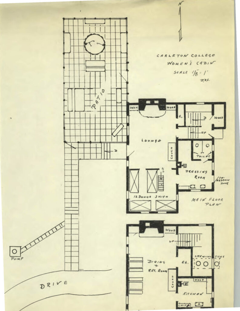
Cowling Arboretum | The History of the Women’s League Cabin
The Women’s League Cabin Chronology
Early 1900’s: Carleton had a strict code of conduct for women. Some rules included a curfew, dress code, and restrictions on when and where women were allowed to socialize with men. In response, the women of Carleton advocated for a “Women’s League” to push back on these rules.
1911: The women of Gridley Hall (one of the main female dorms on campus) unanimously voted in favor of the “Women’s League” which would allow representatives to alter the code of conduct.
1917: The organization was first referred to as the Women’s Student Government Association in the Carletonian (the college’s newspaper), occasionally abbreviated to W.S.G.A.
1928: The Carletonian reported that the women students voted to officially change the W.S.G.A to the Women’s League.
1930s: The Women’s League became much more established. The entire female student body automatically joined the league upon matriculation and the league had officers and multiple councils. Each dorm had its own separate house council and these councils were brought together in the inter-dorm council. They started a campaign to build a cabin in Carleton’s newly acquired Arboretum. The cabin was meant to provide a space away from campus for the women of Carleton
Mid 1930’s: An intense fundraising campaign was required in order for the cabin to be built. In fact, while the cabin was being constructed, there was a funding shortage. The Women’s League was able to secure funding and finished building the cabin on its own.
1939: The cabin was completed, with only women allowed to use it. The cabin was extremely popular with 305 women using it within its first year of completion. The cabin’s popularity would only continue to grow.
1952: Along with the cabin’s very low maintenance budget and several break-ins, the Women’s League Cabin was often in a poor physical state.
1969: At the end of the ’60s, the cabin became too expensive for the Women’s League to maintain effectively. The Natural History/Outing Club at Carleton took over control of the Cabin, and all students (no longer just women) were able to use it for the next several decades.
1971: The cabin is officially transferred to the Natural History/Outing Club. They offer to provide any necessary maintenance or repairs and vowed to keep the cabin as a location for meetings and parties.
Late 1970’s: The cabin became a popular location for students, who could contact the cabin caretaker and reserve the cabin for a certain date. On that date, the students would receive the cabin’s key from the caretaker after paying a deposit in case of damage, and could then enjoy their time at the arb’s retreat, and return the key the next day. They were held responsible for any damage caused during their stay. If no damage was noticed, the student’s deposit was returned.
1994: The cabin was temporarily shut down in 1994 because of its bad conditions and safety violations. Later that same year, students petitioned to refurbish the cabin, and the administration appeared to agree with the students and begin plans for improvement.
1998: After refurbishments were deemed too costly, the College decided to demolish the Cabin, although it is unclear when exactly this happened. Many students who had grown to love the cabin were angered by this decision.
For more information on the Women’s League Cabin, visit the Women’s League Cabin Page on the Archaeology in the Arb website. This page provides information on the excavation of the site and the oral histories. Typing “Women’s League Collection” into the Carleton Archives search bar is a great resource for those interested in the documentary history of the Women’s League Cabin.

Cowling Arboretum | The History of Pine Hill Village
Pine Hill Village Chronology
1945: The end of World War II meant a surge of eligible male students returning to Carleton. Carleton had incentives to enroll these students (GI bill benefits for the school, community recognition as a charitable and “patriotic” institution). However, numerous obstacles stood in the way of Carleton collecting said benefits. A lack of housing and Carleton’s policy of not allowing married couples to reside on campus were two main hurdles. To overcome this, the Carleton administration began planning ways to create housingfor the coming influx of veteran students.
December 1945: In an attempt to create more housing, Bruce Pollock, the college’s treasurer contacted Northfield landlords and absent Northfield property owners about the possibility of vacancies that could be occupied by returning veterans. He also reached out to the Northfield Methodist Church resulting in the purchase of Parish House. Lastly, modifications were made to Carleton’s sports stadium to house single male veterans under the bleachers, providing room for 30 students. While these efforts yielded additional space for about 55 students, they were insufficient to house all returning students and did not provide housing for enrolled married couples. Pollock planned to house married veterans in temporary housing units on Carleton’s campus, and then officially applied for federal monetary aid through the Federal Public Housing Administration (FPHA).
1946: Carleton administrators were successful in locating prefabricated units that were used at a prison facility in Algona, Iowa which they thought could be used to construct the temporary housing units. The four barracks arrived at Carleton by the summer of 1946, but were not fit for use by college students and required large amounts of refurbishing. The initial plan was to convert each unit into three, two-bedroom apartments. The task of acquiring enough material to refit prison barracks into college apartments ultimately proved impossible.
1946-1947: Due to these difficulties, the four Iowan units remained unused. Ultimately, the college was forced to settle for seventeen steel units granted by the FPHA. However, due to FPHA delays, it became impossible to finish the units in time for veteran enrollment for the fall term of 1946.
February 1947: The project was ultimately completed toward the end of February, with residents expected to move in within the following year (approximately six months behind schedule).
1950s: The housing units were officially given to the college. Pine Hill Village quickly became a bustling community due to the proximity and shared experiences of the veterans living there. Life at Pine Hill Village was far more family-oriented than life on the rest of Carleton’s campus. Many of the veterans were married or had families and the Village was a way for them to incorporate that lifestyle with their college education. After Carleton stopped enrolling World War II veterans, there was no need for Pine Hill Village. The college eventually demolished the housing units.
For more information on Pine Hill Village, visit the Pine Hill Village Page on the Archaeology in the Arb website. This page provides information on the excavation of the site and the oral histories. Searching “Pine Hill Village” in the Carleton Archives search bar is a great resource for those interested in the documentary history of Pine Hill Village and the legal work behind its creation.


Cowling Arboretum | The History of Waterford Bridge
Waterford Bridge Chronology
1896-1909: The bridge that predated the Waterford Bridge served the area
1909: The Waterford Bridge was built in 1909, replacing the bridge that was there previously. The Hennepin Bridge Company built the bridge for $5,000, using the design of Charles A. Forbes, who was the engineer for Dakota County. The Waterford Bridge is a unique fixture in the landscape of Southern Minnesota. The bridge was one of the first in the area to use rigid connections instead of pinned connections. Even more unique, the bridge’s connections are fastened with bolts instead of rivets. The bridge is known as one of the only surviving camels through truss bridges in the state of Minnesota.
1983: The bridge suffered erosion due to flooding that threatened its survival, although it was rehabilitated using funds raised by the community.
1991: The bridge was closed to vehicles.
2008: Carleton College announces its plan to assist in the replacement of the Waterford Bridge due to the deficiency of the site.
2010: The Waterford Bridge was listed on the National Register for Historic Places for being a significant example of groundbreaking engineering in the state of Minnesota.
2014: A rehabilitation project began on the bridge, utilizing a grant from the National Trust for Historic Preservation. The southwestern abutment was the starting point for the project, and the concrete was replaced. The project is still ongoing as of 2021.
For more information on the Waterford Bridge, check out the Minnesota Department of Transportation that provides further insight into the history and rehabilitation of the bridge.


Quarry Site
This site is believed to be a part of the Prairie Du Chien rock formation, which extends over a large portion of the Midwest. More specifically, it is part of the Shakopee formation, which is a segment of the Prairie Du Chien formation that is located in the upper Midwest. This rock is dolomite, meaning it is limestone that was formed by the accumulation of ancient sea creatures that have hardened over time, and half of the original calcium carbonate has been replaced by magnesium ions.
The general rock pattern is naturally occurring, but the flat bench cut that is found underneath the cliff-like exposures suggests that there has been human interaction with the site. Benches that are this defined are a sign that humans have quarried the rock for the purpose of garnering building material or loose rock.

Conclusions & Discussions
With the WordPress restrictions in mind, we replicated the Arb Website format to the best of our abilities. We initially faced some difficulties regarding image integration, however, we adapted to the situation accordingly and centrally added images that would be most valuable to the reader. The exact fonts from the Arb Website were not accessible on WordPress, but we used what we had available and still made it seem professional. If we were to gain access to the Arb Website directly, we would ensure that the format is followed precisely with the appropriate design tools to make the reader experience as convenient as possible. Through these webpage additions, we hope to provide more relatable local archaeology to the public and motivate them to discover more about the archaeological field of study.
References
Archaeology in the Cowling Arboretum – Millpond Dike. (2021). https://archaeologyinthearb.com/millpond-dike-excavation/.
Archaeology in the Cowling Arboretum – Pine Hill Village. (2017). https://archaeologyinthearb.com/archaeology-pine-hill-village/.
Archaeology in the Cowling Arboretum – Waterford Mill. (2019). https://archaeologyinthearb.com/waterford-mill-2019/.
Archaeology in the Cowling Arboretum – Women’s League Cabin. (2015). https://archaeologyinthearb.com/archaeology-womens-league-cabin/.
Historic Bridges. Historic Bridges – Waterford Bridge (Bridge L3275). (n.d.). https://www.dot.state.mn.us/historicbridges/L3275.html.
Maps, drawings and architectural plans, 1872-2006: Carleton College Archives. Maps, drawings and architectural plans, 1872-2006 | Carleton College Archives. (n.d.). https://archivedb.carleton.edu/index.php?p=collections%2Fcontrolcard&id=2748&q=pine%2Bhill%2Bvillage.
Northfield Historical Digital Collection. CONTENTdm. (n.d.). https://cdm17227.contentdm.oclc.org/digital/collection/NfldHistSoc.
Women’s League Cabin: Carleton College Archives. Women’s League Cabin | Carleton College Archives. (n.d.). https://archivedb.carleton.edu/index.php?p=digitallibrary%2Fdigitalcontent&id=81444&q=women%27s%2Bleague%2Bcabin.